|
|
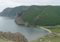
 Uzury is the first bay from Khoboy Cape,a flat valley on eastern part of Olkhon Island. Uzury is the first bay from Khoboy Cape,a flat valley on eastern part of Olkhon Island.
It is the only place on the north of Olkhon where automobile road comes down to the water.
There is a small settlement Usuzy on the shore of Baikal where a permanent weather station is located. If you go up the hill to the right you can see magnificent views of Lake Baikal, the northern part of Olkhon Island and the Maloe More Strait after 1,5 or 2 hours. It is better to go up the path along the shore of Lake Baikal and, then, the ridge of the rocks. When the ridge becomes narrow, it is better to pass on the left side of grassy rock slope. It is better to go down to the Uzury Valley or a path on the Baikal shore through a forest.
 Map of Irkutsk Region Map of Irkutsk Region
 For more details in English, please, add comments and we'll try to answer as soon as possible. For more details in English, please, add comments and we'll try to answer as soon as possible.
|
|
|
|
|
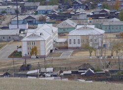
 In Elantsy settlement of Irkutsk Region 4148 people live. There is the management office of the Malomorsky Block of the Pribaikalsky National Park on Lake Baikal. In Elantsy settlement of Irkutsk Region 4148 people live. There is the management office of the Malomorsky Block of the Pribaikalsky National Park on Lake Baikal.
The summer crossing gate on the exit of Elantsy is put and the Pribaikalsky National Park charges entrance fee. There is the final opportunity for a fill-up, there is no fuel filling station on the shore of the Maloe More Strait. You can see three symbolically-rendered posts “serge” tied cloths on 85 km above the bridge across the Angara River.
 Map of Irkutsk Region Map of Irkutsk Region
 For more details in English, please, add comments and we'll try to answer as soon as possible. For more details in English, please, add comments and we'll try to answer as soon as possible.
|
|
|
|
|
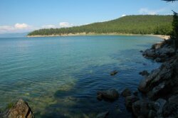
 The Bolshoy Goloustny Cape deeply pushes out into Lake Baikal. Captains prefer to keep the distance from the shore because of frequent winds, storms and shallow waters. The Bolshoy Goloustny Cape deeply pushes out into Lake Baikal. Captains prefer to keep the distance from the shore because of frequent winds, storms and shallow waters.
The estuary of the river is bogged up and it is better not to go the path which is close to Lake Baikal.
Wintering place was build in the seventeenth century in the Goloustny Cape. The name “Goloustny” is characterized the place and means a steppe, treeless, bare estuary of the river which was formally called Idin-Gol. The river derived its name from the cape. Now the river is also named the Goloustnaya River. The population of Bolshoe Goloustnoe settlement is more than 600 inhabitants. The river length is 125 km.
There is a Recreation Centre represented by Buryat yurtas on the upstream side from the Shantuysky Bridge, 6-7 km from the shore of Lake Baikal.
 Map of Irkutsk Region Map of Irkutsk Region
 For more details in English, please, add comments and we'll try to answer as soon as possible. For more details in English, please, add comments and we'll try to answer as soon as possible.
|
|
|
|
|
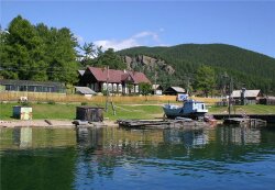
 In Bolshie Koty (“Big Cats”) settlement there is the Lake Baikal Museum and the Biology Institute Aquarium. The Lake Baikal Museum was founded by Professor M.M. Kozhov. There are more than 400 various exhibits, a great collection of Baikal insects: bugs, butterflies and dragonflies. There is also a permanent scientific station, where students from Siberia do their summer practical works. Bolshoe Koty settlement is small and getting used for suburban life (for dachas), old houses pre-empted by urban residents for summer rest on the shore of Lake Baikal. In Bolshie Koty (“Big Cats”) settlement there is the Lake Baikal Museum and the Biology Institute Aquarium. The Lake Baikal Museum was founded by Professor M.M. Kozhov. There are more than 400 various exhibits, a great collection of Baikal insects: bugs, butterflies and dragonflies. There is also a permanent scientific station, where students from Siberia do their summer practical works. Bolshoe Koty settlement is small and getting used for suburban life (for dachas), old houses pre-empted by urban residents for summer rest on the shore of Lake Baikal.
The abandoned gold-bearing placer of merchant Patushinsky is located some kilometers from Bolshie Koty settlement in front of the Skriper Rock, not far from the shore of Lake Baikal, in in Sennaya Pad (Russian word for “lowland”). There are many vertical mines with a flank drift which are still preserved in a good condition, where it is possible to get down. Along the stream gap the wooden chutes of the gold-miners are still met. People stroke gold not only in river sands and gravels but also on the shore of Lake Baikal. Gravels near the estuaries of the Bolshie Koty and Malye Koty Rivers were mined from the bottom of Lake Baikal, from a float in summer and from an ice-hole in winter.
 Map of Irkutsk Region Map of Irkutsk Region
 For more details in English, please, add comments and we'll try to answer as soon as possible. For more details in English, please, add comments and we'll try to answer as soon as possible.
|
|
|


