|
|
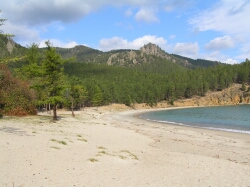
 Chivyrkuisky Bay is located in the north-west of Lake Baikal and included in the Zabaikalsky National Park in the Republic of Buryatia. Chivyrkuisky Bay is located in the north-west of Lake Baikal and included in the Zabaikalsky National Park in the Republic of Buryatia.
The Zabaikalsky National Park is located in the central part of the western shore of Lake Baikal. This is a goltsy mountain-taiga zone where alpine meadows and alpine tundra of the Barguzin Range and the Svyatoy Nos Peninsula, mountain coniferous forests of the Baikal Depression slopes, dry pine forests of sand lake plains with dunes along the shore of the Barguzinsky Bay encroaching on bogs of the Chivyrkuy Isthmus alternate. The Chivyrkuisky Bay is separated from Lake Baikal by the Svyatoy Nos Peninsula on the west, by the Svyatonossky Isthmus on the south and by the mainland on the east and the north-east.
The area of the Chivirkuisky Bay is 270 square kilometers.
 on Map of Buryat Republic on Map of Buryat Republic
 For more details in English, please, add comments and we'll try to answer as soon as possible. For more details in English, please, add comments and we'll try to answer as soon as possible.
|
|
|
|
|
 Water distance from Listvyanka Settlement to Peschanaya Bay is about 80 km, motorboat voyage time is 5 hours. Water distance from Listvyanka Settlement to Peschanaya Bay is about 80 km, motorboat voyage time is 5 hours.
Peschanaya Bay is one of the most famous, interesting and beautiful places around Lake Baikal. The creator of Lake Baikal seemed to feel inspiration in that place and try to shape very beautiful rocks, mountain slopes and the bay oval beach which he placed on a small area of Lake Baikal.
Peschanaya Bay is the sole place on the lake where one can see miraculous "walking-on-stilts" trees, a real wonder of Baikal. The trees have risen above the earth on their stilt-like roots, from under which water and winds blow out the soil. Climate of Peschanaya Bay is mild and the bay is famous for plenty of sunny days. It is the only place in Eastern Siberia, where the average annual temperature is above-zero
 Peschanaya Bay on Map of Irkutsk Region Peschanaya Bay on Map of Irkutsk Region
|
|
|


