|
|
 During round trip Listvyanka Ц Peschanaya Bay Ц Listvyanka you can visit one of the most beautiful and frequent places on the lake Baikal Ц the famous Peschanaya Bay During round trip Listvyanka Ц Peschanaya Bay Ц Listvyanka you can visit one of the most beautiful and frequent places on the lake Baikal Ц the famous Peschanaya Bay
Peschanaya Bay is a sand beach, plenty of sunny days, picturesque sceneries, unique natural monuments and (rocks и Baikal Caves).
One of that natural monumets is Bolshaya and Malaya Kolokolnya Rocks. Rise above the lake surface to a height of about 100m, the rocks rock jut out into Lake Baikal, sheltering the bay from stormy winds. The Bolshaya Kolokolnya rock that you can climb up the special path affords the all-round view on Lake Baikal.
 For more details in English, please, add comments and we'll try to answer as soon as possible. For more details in English, please, add comments and we'll try to answer as soon as possible.
|
|
|
|
|
 Yada is a village of the Kuytunsky District of Irkutsk Region. The name derives from the Buryat word Уyadaa or yaduuФ which means Уpoor, weakФ. There is the legend of local Russians with relation to the origin of this word. У One day a part of the Yermak Cossacks lost behind, went in circles and finally reached the shore of the Oka River. They were thin, shabby, hungry people. When they saw the river, they caught fish, cooked fish soup with salt and ate as much as one can hold. And then the Cossacks said УWhat a delicious meal (yada in Od Russian)Ф. ThatТs the origin of the word YadaФ. But as you know this story is an entire fabrication. Yada is a village of the Kuytunsky District of Irkutsk Region. The name derives from the Buryat word Уyadaa or yaduuФ which means Уpoor, weakФ. There is the legend of local Russians with relation to the origin of this word. У One day a part of the Yermak Cossacks lost behind, went in circles and finally reached the shore of the Oka River. They were thin, shabby, hungry people. When they saw the river, they caught fish, cooked fish soup with salt and ate as much as one can hold. And then the Cossacks said УWhat a delicious meal (yada in Od Russian)Ф. ThatТs the origin of the word YadaФ. But as you know this story is an entire fabrication.
Yalga is a stow in the Olkhonsky District of Irkutsk Region.
Yamat is an ulus (an inhabited locality type of Buryats) of the Alarsky District of Irkutsk Region. The name came from the Buryat word УyamanФ( a female goat) and УyamatФ (goat inhabitat).
Yandy is a stow in the Ust-Udinsky District of Irkutsk Region. УyandyФ or Уyandy-miФ means УquackФ in Evenki, i.e. Yandy is the former place for shaman rituals. Before the creation of the Bratsk Reservoir there was Yandy settlement founded in the 17th century.
 For more details in English, please, add comments and we'll try to answer as soon as possible. For more details in English, please, add comments and we'll try to answer as soon as possible.
|
|
|
|
|
 Rabochee is an outskirts of Irkutsk. In 1799 the WorkerТs or Craft House was opened near the Sarafanovka River and over the Ushakovka River. There were built different handicraft manufactures around the WorkerТs House. As a result, the workerТs settlement was appeared near manufactures. The settlement had been named as the Borisoglebskaya Sloboda (Quarter) after Saint Boris and Gleb for a while. Growing workerТs population gave the name of this district: Rabochee (WorkerТs) outskirts. Rabochee is an outskirts of Irkutsk. In 1799 the WorkerТs or Craft House was opened near the Sarafanovka River and over the Ushakovka River. There were built different handicraft manufactures around the WorkerТs House. As a result, the workerТs settlement was appeared near manufactures. The settlement had been named as the Borisoglebskaya Sloboda (Quarter) after Saint Boris and Gleb for a while. Growing workerТs population gave the name of this district: Rabochee (WorkerТs) outskirts.
Rassokha is an urban-type settlement of subordination of Shelikhov. This settlement is located in a УrassokhaФ (in Siberian dialect), a conjunction of the Big Olkhinka and the Small Olkhinka Rivers, tributaries of the Irkut River.
Rytyi is a cape in the north-west of lake Baikal. The name came from the last century. This word means УdelveФ. There is, indeed, a very deep underwater depression between shore mountains and the Akademichesky submerged ridge.
Paberega is villages of the Tulunsky District of Irkutsk Region on the shores of the Oka River, the Iya River and others. It comes from Russian word УpaberegФ (an offshore coastal strip which crops out at medium or low water level).
 For more details in English, please, add comments and we'll try to answer as soon as possible. For more details in English, please, add comments and we'll try to answer as soon as possible.
|
|
|
|
|
 Administrative-territorial Division of Buryat Republic Administrative-territorial Division of Buryat Republic
The Republic of Buryatia is a republic, one of federal subjects of Russia. The Buryat Republic comprises 21 districts, seven of them are equated with northern regions of Russia. In the Republic of Buryatia there are 5 cities of republican status (Gusinoozersk, Kyakhta, Severobaykalsk, Babushkin, Zakamensk) and urban-type settlements (Zaigraevo, Barguzin, Taximo, Kamensk and others).
Every district, city, urban-type settlement and village of the Buryat Republic is headed by the elected head of relevant local administration and the head forms administration.
The capital of the Republic is the city of Ulan-Ude.
 Map of Buryat Republic Map of Buryat Republic
 For more details in English, please, add comments and we'll try to answer as soon as possible. For more details in English, please, add comments and we'll try to answer as soon as possible.
|
|
|
|
|
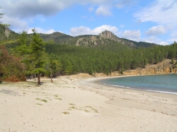 Water distance from Listvyanka Settlement to Peschanaya Bay is about 80 km, motorboat voyage time is 5 hours. Water distance from Listvyanka Settlement to Peschanaya Bay is about 80 km, motorboat voyage time is 5 hours.
Peschanaya Bay is one of the most famous, interesting and beautiful places around Lake Baikal. The creator of Lake Baikal seemed to feel inspiration in that place and try to shape very beautiful rocks, mountain slopes and the bay oval beach which he placed on a small area of Lake Baikal.
Peschanaya Bay is the sole place on the lake where one can see miraculous "walking-on-stilts" trees, a real wonder of Baikal. The trees have risen above the earth on their stilt-like roots, from under which water and winds blow out the soil. Climate of Peschanaya Bay is mild and the bay is famous for plenty of sunny days. It is the only place in Eastern Siberia, where the average annual temperature is above-zero
 Peschanaya Bay on Map of Irkutsk Region Peschanaya Bay on Map of Irkutsk Region
|
|
|
|
|
 Alzamai is a town of Nizhneudinsk city subordination. Alzamai is a town of Nizhneudinsk city subordination.
Foundation of Alzamai: in 1899, incorporated in 1955.
Geographic Coordinates of Alzamai: 55∞ 35' N., 98∞34' E, located in the Eastern Sayan Mountains, on the Toporok River in the basin of the Angara River.
Zone Standard Time: MSD (Moscow Daylight Time) +5 hours
Total Area of Alzamai: 45 km2.
Population of Alzamai: 13 000 (1959); 9 000 (1989); 8 800 (1998); 7 200 (2006).
Renamings: no.
 Map of Irkutsk Region Map of Irkutsk Region
 For more details in English, please, add comments and we'll try to answer as soon as possible. For more details in English, please, add comments and we'll try to answer as soon as possible.
|
|
|
|
|
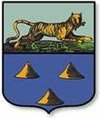 Nizhneudinsk is a city of the district subordination, the centre of the Nizhneudinsky District of Irkutsk Region. Nizhneudinsk is a city of the district subordination, the centre of the Nizhneudinsky District of Irkutsk Region.
Foundation of Nizhneudinsk: in 1648, incorporated in 1783.
Town of City Subordination: Alzamai.
Geographic Coordinates of Nizhneudinsk: 54∞ 56' N, 98∞ 58' E, located at the foot of the Eastern Sayan Mountains, on the Uda River in the basin of the Yenisei River.
Zone Standard Time: MSD (Moscow Daylight Time) +5 hours
Total Area of Nizhneudinsk: 98 km2.
Population of Nizhneudinsk: 10 400 (1926); 38 800 (1959); 43 700(1989); 43 200 (1998); 38 400 (2006).
Renamings: no.
 Map of Irkutsk Region Map of Irkutsk Region
 For more details in English, please, add comments and we'll try to answer as soon as possible. For more details in English, please, add comments and we'll try to answer as soon as possible.
|
|
|
|
|
 Tulun is a city of region subordination and the centre of the Tulunsky District of Irkutsk Region. Tulun is a city of region subordination and the centre of the Tulunsky District of Irkutsk Region.
Foundation of Tulun: in the second half of the eighteenth century; incorporated in 1922-1924 and in 1927.
Geographic Coordinates of Tulun: 54∞ 37' N, 100∞ 28' E, located on the Irkutsk-Cheremkhovo Plain, on the Iya River, in the basin of the Angara River.
Zone Standard Time: MSD (Moscow Daylight Time) +5 hours
Total Area of Tulun: 135 km2.
Population of Tulun: 28 000(1939); 41 800 (1959); 52 900 (1989); 53 700. (1998); 49 400 (2006).
Renamings: no.
 Map of Irkutsk Region Map of Irkutsk Region
 For more details in English, please, add comments and we'll try to answer as soon as possible. For more details in English, please, add comments and we'll try to answer as soon as possible.
|
|
|
|
|
 Zima is a town of region subordination and the centre of the Ziminsky District of Irkutsk Region. Zima is a town of region subordination and the centre of the Ziminsky District of Irkutsk Region.
Foundation of Zima: in 1743; town status in1922.
Geographic Coordinates of Zima: 53∞55′N 102∞03′E; located on the Irkutsk-Cheremkhovo Plain, on the Oka River, a tributary of the Angara River, near the inflow of the Oka River into the Zima River.
Zone Standard Time: MSD (Moscow Daylight Time) +5 hours
Total Area of Zima: 54 km2.
Population of Zima: 26 800 (1939); 38 500 (1959); 41 800 (1989); 36 900 (1998); 34 100 (2006).
Renamings: no.
 Map of Irkutsk Region Map of Irkutsk Region
 For more details in English, please, add comments and we'll try to answer as soon as possible. For more details in English, please, add comments and we'll try to answer as soon as possible.
|
|
|
|
|
 Cheremkhovo is a town of region subordination and the centre of the Cheremkhovsky District of Irkutsk Region. Cheremkhovo is a town of region subordination and the centre of the Cheremkhovsky District of Irkutsk Region.
Foundation of Cheremkhovo: in 1772, town status in 1917.
Town of Subordination: Svirsk.
Geographic Coordinates of Cheremkhovo: 53∞13′N 103∞02′E; located on the Irkutsk-Cheremkhovo Plain.
Zone Standard Time: MSD (Moscow Daylight Time) +5 hours
Total Area of Cheremkhovo: 117 km2.
Population of Cheremkhovo: 56 000 (1939); 121 700 (1959); 73 600 (1989); 70 500 (1998); 55 600(2006).
Renamings: no.
 Map of Irkutsk Region Map of Irkutsk Region
 For more details in English, please, add comments and we'll try to answer as soon as possible. For more details in English, please, add comments and we'll try to answer as soon as possible.
|
|
|
|
|
 Usolye-Sibirskoye is a town of region subordination and the centre of the Usolsky District of Irkutsk Region. Usolye-Sibirskoye is a town of region subordination and the centre of the Usolsky District of Irkutsk Region.
Foundation of Usolye-Sibirskoye: в 1669, town status in 1925.
Geographic Coordinates of Usolye-Sibirskoye: 52∞50′N 103∞34′E; located on the Irkutsk-Cheremkhovo Plain, on the left side of the Angara River.
Zone Standard Time: MSD (Moscow Daylight Time) +5 hours
Total Area of Usolye-Sibirskoye: 73 km2.
Population of Usolye-Sibirskoye: 20 000 (1939); 48 500 (1959); 106 600 (1989); 104 300 (1998); 86 900 (2006).
Renamings: Usolye (1669-1940)
 Map of Irkutsk Region Map of Irkutsk Region
 For more details in English, please, add comments and we'll try to answer as soon as possible. For more details in English, please, add comments and we'll try to answer as soon as possible.
|
|
|


